Monday, January 24, 2011

Time for a hike...

So at the end of a day off, being frustrated being stuck indoors as it was blowing about 30-35 mph, light snow and about 10 degrees ambient, I said screw it and went for a hike.  They issue us gear to survive days at -40 below so why not.  Observation hill is the highest peak in the camp at around 700' or so up nice knife edge trail.  It was a bit blustery but once at the top there is a nice rock formation to block the wind giving me a chance to cool down a bit. 

At the peak of the hill is what's called "Memorial Cross" dedicated to Robert Falcon Scott and polar party that perished in 1912.  Inscribed on the cross bears the quote from Ulysses: "To strive, to seek, to find, and not to yield"
Memorial Cross atop Observation Hill
On top "Ob" Hill

Our local scavenger the Skua hanging out with on top the hill. They're
about the size of a chicken and will eat anything not tied down.

Looking back towards Mcmurdo.  I met up with a Kiwi who was out for a hike as well.

Sunday, January 23, 2011

And now for a little history...

Our camp has some history to it.  First of Mcmurdo is named after LT Archibald McMurdo, an officer aboard the Terror.  Terror was one of three ships, Terror, Erebus and Terra Nova that were the first to penetrate the Antarctic Pack Ice in 1841 with James Clark Ross' expedition, hence Ross Island that I am on right now.

In 1901 Robert F. Scott pentrated the pack ice aboard Discovery and wintered over here in Winter Quarter's Bay, where McMurdo is right now.  His expediation erected "Scott's Hut" on what is known as Hut Point Penninsula. 

Scott's Hut from Hut Point Pennisula.  Winter Quarter's Bay, McMurdo
in the background.
This was base camp for Scott's early sledging parties where they deployed from in 1901-1903 and 1910-1913. Just to the southwest of  Scott's Hut lies Vince's Cross which was erected in 1902 in memory of Seaman George T. Vince who disappeared over Arrival Heights (a peak just behind McMurdo leading to the Erebus Glacier).  

Vince's Cross


Hut Point Penninsula. Arrival Heights is behind where the white dome is atop the hill.
Cape Royds is to the left.
 In 1902 Scott and Ernest Shacklton left Scott's hut on their first real attempt to reach the South Pole, which was not successful until 1911.
Scott's Hut
Seal carcass atop camp supplies left behind and never reclaimed by Scott's
party as they perished on their return trip from the South Pole expedition in 1912.
As a disclaimer, this is all real.  These aren't "recreations" of the sites.  This environment is so dry and moisture free, everything is preserved here perfectly.  Hundred year old food supplies still lay inside the hut as does expedition gear, etc.  It's actually a bit spooky.  The hut is a historical site and locked up.  It is opened on special occassion for historical studies but not open to the public. 

Hope that help's paint a nice grim reality of the fate of many early explorers here.  Having such history in my "backyard" is a nice reminder of the suffering these expeditions went through here when I start to complain of a little frost nip on my way from my heated room to the heated galley to eat a fresh hot meal!

It's science Sunday

So it's Sunday here.  My weekend.  Slept in, woke up to snow and 25 knot winds, about 10 degrees F today.  It's still getting cooler.  So it was a nice wake up walk to brunch in the galley.  They take out the "good stuff" for the weekend.  I stuffed myself nicely.  Now everything is pretty much buttoned up on Sundays so I tried figuring out what to do.  There is board up daily showing what's happening and when around "town". 

I hopped on a shuttle to drive to the neighboring camp run by the Kiwi's (New Zealanders) called Scott Base named after Robert Falcon Scott who first landed here in 1901 in the Discovery. I went to their store to compare what kind of trinkets they were selling and found a couple items to bring back.   I'm ticked I didn't bring my camera because their camp is right along the sea ice edge where there are crevasses leading to exposed water and with that a couple hundred Weddell Seals were out sunning themselves perhaps after munching on an Adelie penguin.

Either way, I came back to base and went over to the Crary Labratory where the scientists bring their field work back to analyze and earn thehir grant money back.  There are hundered of projects going on varying from Glaciology, microbiology, genetics, atmospheric, particle physics, you name it there are a hundered PhD's studying it.

The front of the Crary Lab
Right off the bat we were introduced to one of the marine biologists who has been studying the Adelie penguin populations on Ross Island, the two largest in the world with somewhere around 300,000 breeding couples.  He's been doing this for upwards of 15 years here.  You can see his work at http://www.penguinscience.com/
Adelie Penguin researcher David Ainley
  So we were led around the facility by a grad student who took us through multiple labs, introduced us to scientists that were working on their projects and showed us a snapshot of what they were doing.
Our tour guide explaining how many PhD's it take to screw in
a light bulb.  Actually its a special light that is dipped into the lakes
in the dry valleys (see previous post) to help measure bio activity
year round in the water beneath the lake ice.
Next wandered around and were introduced to a collaborative project called the Dry Valley Long term Ecological Research (LTER) project.  A number of different sciences combine together to understand a particular ecosystem better by sharing work together and jointly learning more together than they would have on their own.  This guy studies some of the microbiology, specifically an earthworm that is the dominant predator in the ecosystem--everything is relative at -50 degrees F.  Soon after the project, the pilots jokingly began calling the project members "wormherders" which is now the name of there base camp in the Taylor Valley. 
A wormherder
 We then went down into the a place colder than the outdoors where they kept projects from the field really cold. The lab / freezer is -20 degrees and we met an Oregon State grad student who is working on some 50,000 year old ice cores.  They contain gas bubbles that trap the atmospheric conditions at the time so if you melt the sample and extract the gases, you get a glimpse at the air composition, therefore the climate (CO2 and Methane levels specifically).
Holding a piece of 50,000 year old history
Touching the touch tank
 We finally ended up in the aquarium where it was fairly quiet--most of the science there was earlier in the season.  There are huge tanks throughout and a small tank for display containing some local sponges and sea anemone (I think that is already plural : )  ).

Some local critters
 After the tour I wandered around.  They have all kinds of projects on the walls to read up the latest stuff. Thank God I have a science background to be able to slightly understand these.  I stumbled onto a neat find found in the transantarctic mountain range which bisects the continent roughly in half.  The picture below is a 270 million year old tree stump.  Yes stuff grew here.  Yes it has been warm before. Interesting stuff.
An ancient stump from the Queen Alexandra Range in central Antarctica
 Well, I hope that was enlightening.  Tonight there is a "science talk" with one of the previously mentioned scientists focusing on the oceanography of the Ross Sea.  Should be fun! Back to school. Cheers to all!

Saturday, January 22, 2011

My new office view

So for four hours yesterday I got my first flight of many to come in.  Trying to explain what exactly I do can be a little confusing, but here goes nothing--I'm in charge of providing US gov't aviation oversight to 2 flying contracts going on down here that have been in existence for 14 years or so (pretty much since the US Navy's VXE-6 decommissioned).  One of the side benefits of the job is getting to fly with these science support missions routinely as a way to monitor the performance of support these contractors provide.      
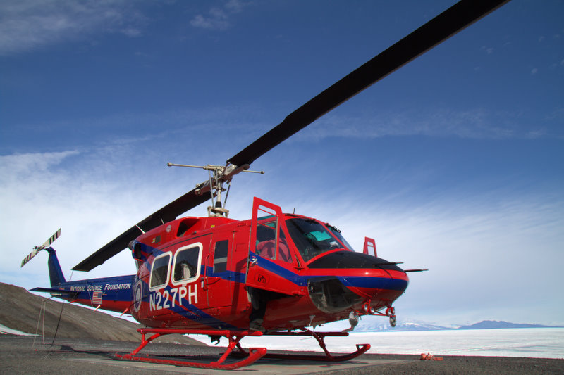
PHI's Bell 212
 Eitherway, yesterday I got to go out with a salty retired US Coast Guard pilot and help him for the afternoon as we broke down a deep field camp in what's known as the "Dry Valley's".

They are a glaciologist's dream.  As the ice off the polar plateau flows, it carves out this section of granite leaving its mark on the constantly changing topography.  The shear scope of these glacial flows is epic. Words are difficult in describing the shear beauty along each Valley. 

So we took off from McMurdo's helipad in one of the Bell 212's to the east (direction is all a bit different at the bottom of the world--this is a whole different subject for later).  We transited across the Ross Sea ice towards the valleys which took about 30 minutes.  We proceeded over the western edge of the sea ice and entered the Taylor Valley flying close to "map of the earth" low level flying.  The winds were light in the valleys so turbulence was minimal and we proceeded up valley towards Bonney Lake which is at the outflow of the Taylor Glacier.  We proceeded to head to Bonney Lake and do 4 round trips to the camp to pick up gear, empty on the return leg, giving us the freedom to explore and see the surrounding beauty that is Antarctica. There is so much I could say but hopefully the pictures speak for themselves.  This was an amazing flight and can't believe this is my job.
 

Lake Fryxell at the head of the Taylor Valley
 
Approaching the field camp at Bonney Lake


Lake Hoare at the base of the Suess Glacier


Continuing up the Taylor Valley
  

Picking up sling loads at the Bonney Lake camp LZ
 
On the deck at Marble Point -- fuel, food and a stretch


Me trying to figure out the voodoo that is flying helo's


Gargoyle Ridge in the Asgard Range in the Wright Valley


The Schlatter Glacier and snow field tucked between the mountains of the Asgard Range


The confluence of the Taylor and Ferrar Glaciers, the polar plateau ice fall is in the far background
   
The Rhone Glacier
  

The Lacroix and Suess Glaciers flying down valley to drop off a load of gear back at Marble Point


The ice edge en route back to McMurdo.  The edge itself is a sheer 150' ice cliff. 
  

Departing Marble Point to return to McMurdo after 4 hours of Valley Flying!  This is Mt Erebus, 12,400' volcano which is directly above Mcmurdo station. 


The ice breaker Odin in the channel between Mcmurdo and ice edge.  It keeps the lane open for the resupply and research vessels that come into port. Mt Erebus in the background.


On final into Mcmurdo.  This is "home" to about 1,000 of us.  My room is on the left edge of town.  Everything is black because we are on volcanic soil.  Again Mt Erebus looms in the background.


Well, that's about it! It's Saturday, the end of my "week", hope to go hiking to a penguin colony tomorrow if its not too cold. The temps finally beginning to become normal--its around 12-13 degrees F now.  The next few weeks will really start dropping quickly too.  And yes I am serious about the penguins....

Thursday, January 20, 2011

Learning the ropes

Not much to say other than it is now time to start learning how to do the job I got hired for.  In a nutshell I'm overseeing two aviation contracts that the Department of Interior's Aviation Management Directorate in Boise, ID manage for the National Science Foundation who own the ice here.  These two contracts encompass about 10 fixed wing assets and 5 rotary wing (helo) assets. 
The flying is diverse to say the least.  In a typical season probably around 1500 hrs for helicopters and 3500-4000 for the fixed wing--this is in a 4 month period.  The scope is also fairly jaw dropping in that the flying is all over the continent, a continent that is nearly double what the lower-48 cover--and these guys are doing it on their own with no support in the deep field.  I'm going to start flying with these guys in the next week and can't wait to get out and see the day-to-day ops. 

Beyond that, there are the acronyms.  I speak Navy and general pilot acronyms.  I know need to take a crash course in Antarctic Aviation and Mcmurdo-ese.   So my nights are busy reading about programs, contracts, learning where all the camps are in the field and trying to remember the 25 names of equally important people I brief daily.  To quote an old Far Side cartoon, "My brain is full". 

Well, I am off to my room to get ready for some party where a bunch of distinguished scientists are touring here and planning the future of the NSF's program direction.  So back to my dorm...oh, here's a shot of that too, nothing fancy. I promise...it's better than a snow cave!

Wednesday, January 19, 2011

Out of the frying pan and into the Freezer...

Sorry for the delay in the updates.  The Kiwis have little Internet and when they did it was wicked expensive. Antarctic Internet is free, however unavailable out in the field.  So I am back and plugged into the mothership as of an hour ago or so. 

Monday's flight down to "the ice" as everyone calls it was delayed for one of the odder reasons -- it was too warm to land in Antarctica.  Let me explain, it is summer here, there are no traditional (paved, earthen, prepared surface) runways either.  Mcmurdo station is on an Island (Ross Island) and it is surrounded by the Ross Sound which is frozen.  The sea ice provides a runway for the early summer (Oct-Dec) and then it is deemed not safe after as the  sea ice thins and weakens -- not suitable for 300,000 pound aircraft to pound into it. After December, the majority of flight ops happen from Pegasus Field.  It is what's called "shelf ice" which is basically glacial ice flow from the continent into the sea (which is frozen). 

So back to the story...When the temperature is around freezing, which it has been at the "high" for the day recently, a thin film of water puddles on the runway.  This greatly reduces what the C-17 aircraft can haul down on each flight.  So to mitigate this issue, my flight was delayed here by 12 hrs with a new planned takeoff of 11pm local which would get us here about 4:15am.  So another day wandering about Christchrurch to wonder what awaits in Antarctica.  We all showed up at our planned show time of 3 hrs prior, cleared customs and dressed up in our finest "extreme cold weather" gear which even in the evening's 60 degree air was "extremely hot" gear.
 
We received a few safety briefs and watched an arrival video which pretty much said "sit down and shut up" once aboard the cargo plane. 

The flight was fairly uneventful.  I grabbed a wall seat across from a pallet with a 20,000 snow cat on it. 

This was beginning to feel real now.  The 75 passengers around me were excited, nervous, some slept, some read, some conversed. 

Some had this look of "what the heck am I doing here?" on their faces.  I think I had a grip on my emotions.  I was excited with camera in hand talking to folks, asking what everyone is doing once they arrive. 

The majority of the folks were going about the "Palmer" which is an oceanographic research vessel for a month or so.  The remainder were a mix of smaller projects and support staffers. 
I awoke to the "two hours out" call signifying we were continuing to the continent and to start strapping on your survival gear if you had stripped down on the plane.  There are about 4-5 portals in the cargo area of the jet to look out and the seascape of white was everywhere.  Broken sea ice gave way to solid sea ice, shelf ice leading to glaciers and mountain peaks coming out through the sea of white. 


Finally we had to take our seats for landing. 

Once we taxied in, the unknown awaited.  "Everybody up", as we waddled to the door with all of our gear.  As we walked to the light of the door, the glare of the snow was already filling the cabin.

We hopped out to witness one of the single most spectacular landscapes I have ever seen.  It was breath taking.  A flat plain of white with peaks reaching skyward in every direction. 


Unfortunately my moment of zen was cut short as we had to load up onto a giant converted ice bus that had to take us from Pegasus field back to Mcmurdo station which was about 15km away, or 45 minutes. 

After settling in to the drive I started up a conversation with an Air National Guard pilot who flies the "ski"-130's (LC-130's with ski's for landing gear).  We chatted for a bit and then the driver stopped the vehicle to inform us of a greeting party, a family of 3 emperor penguins in the road.  How cool? They are huge as far as penguins go--about 3 - 3 1/2 feet tall.  We gave way and let them go on their way. The road continued along the shelf ice and where the shelf ice met with the sea ice was a transition that required some serious maneuvering between jagged 10-15 ft ice fractures where the tidal movement of the sea ice caused this natural obstruction. Once through the obstructions, we transitioned onto Ross Island, terra firma, where Mcmurdo station is located (See aerial photo in an early post of mine for reference).  The island is volcanic and is surrounded by various cones and a number of full volcanoes, one of which, Mount Erebus is 12,400'.  The ground for the most part is clear of snow and the "road" is volcanic soil and rock.  After another 500' up the switch backing road, and about 10 minutes driving we arrived into Mcmurdo Station or "Mactown".
We hopped of the giant bus (which was named "Ivan the Terra-bus" by the way), and went into one of the central buildings, the "Chalet" as its known. 

After getting an initial welcome brief, and what looked like a few not-applicable lectures, my counterpart Mark here came and found me to welcome me and apologize already for what I had to do next.  Although sleepless for about 22 hrs, he informed me if I wanted to get out into the deep field camps here (bases far inside the continent far from any support what-so-ever) I had a mandatory class to attend that started at 8am!  Its formally called "Snow School" but locally referred to as "Happy Camper".  Going to these deep camps where we fly into routinely is required for my job so, sleep or not, I said yes.  I grabbed my stuff, found my checked bags and Mark showed me off to my new "home".  He and I are roommates, so far so good. After a quick bite to eat, I ran off to class. 
In a nutshell this is an extreme cold weather survival school.  We are issued extreme cold weather gear and you never leave the confines of mcmurdo without your bag of gear.  Anything into the field requires an additional bag issue, a survival kit.  This course is to get me familiar with the gear and give the confidence to use it and give me the best chances for survival when it gets "really bad" here.  Weather here right now is not too bad, temps in the hi 20's.  The locals are shocked.  Those that have been here many seasons say it has never been like this before.  Regardless, the weather can change in an instance to 150 mph winds, zero visibility and -40 F in minutes, and is not uncommon.  We spent a bit of classroom time first and headed out to the field in a track vehicle which dumped us off about 20 minutes away in an shelf ice field.   We learned how to use the different tent types but spent a good portion of the afternoon creating wind walls and digging trenches, sometimes called "coffins" for survival situations. 

The shelf ice is formed from years of snow compacting upon itself and the top layers above the "blue" ice is thick packed snow.  We cut blocks out with snow saws and avalanche shovels--all gear we had in our survival packs.  So in the matter of an hour's work, we had 4 tents up, 4 trenches dug, a 25 foot long, 3 foot tall wind wall and a kitchen built--a 4 foot deep, 10'x10' hole, with shelves, a stove top, table, chairs and a 3 ft wind wall built all from ice. 


Very hard work, very rewarding...can I sleep yet? No, time to cook.  Wind had picked up to about 30 mph sustained and temps around 15-20 degrees.  After making water first from glacial ice we got it boiling and proceeded to fix some dehydrated rations and soups.  Now can I sleep?  It's been 38 hrs or so.   I needed it.  Yes. 

Now about that sun.  Its at about 20 degrees declination, all the time.  24 hrs of light.  Great sleeping weather.  I could have cared less.  I stripped down to my base layer and crawled in my -40 degree rated bag, drank about a liter of water, threw some Dave Matthews on my iPod and passed out for 8 hrs. 
I woke up this morning at 5:30am and threw my gear back on.  We made some more water, boiled it after an hour made some coffee and proceeded to break down the camp. 

The remainder of the morning was going through different survival scenarios. One was having a single person's survival kit with 10 people to share after a vehicular accident, approaching storm, injuries and 800 miles from any other camp.  Interesting.  The second was a search and rescue scenario in zero visibility after a member failed to return from a bathroom break.  Again, interesting and eye opening.  We wrapped up the field work and arranged our transport back to the base and debriefed. 

Wow.  What a class.  What an experience to kick things off.  Finally showered after a few days.  Getting my thoughts together, looking over pictures and realizing what a great job this is going to be.  Everyone I have met here is incredibly friendly and sharp.  People have great attitudes about life, nature, science, etc.  I am hoping these next few weeks of learning prove to be similarly enjoying.  Hopefully I can write down stuff in shorter bursts but this was such an experience I wanted to share it all.  Next up how to traverse sea ice class and Snow School /Mountaineering (part 2)! Talk to you all soon! Cheers from 80 degrees south!