Baby steps. That's a method to success in many difficult projects. This latest helicopter based skyTEM project is one of those. We are in the proving grounds now. We have crawled, walked and are beginning a light jog now. Two days ago the array I wrote about in my last entry was flown around the vicinity of Mcmurdo Station in its initial calibration flights and was ready to re-position for beginning actual data collection in the Dry Valley region of Antarctica. This is the story of the first couple days of field test flying and the success seen so far.
Initial hook up of the day to the skyTEM array
After being asked a few times what this gear was and how it works, I'll try to reexplain a but with my simple pilot brain. The array is constructed from kevlar reinforced wood. The cross members (the white pieces on the truss) are actually only PVC. The joints are actually only held together with kevlar cords. The rig is set to fly level around 25 knots, they can adjust it accordingly based on wind speeds, the quality of the data being processed, etc. The wind limit is around 45 knots--that's really a structural thing as the drag will fold the array in two if exceeded. Its rather simple and ingenious overall. That's why the people in the tent around me have a collection of 4-5 PhD's amongst them. As far the the operation, there is a generator in the sling that sends power to a bank of capacitors that send about a 500 amp pulse through a coil that goes around the frame's exterior. That happens at about a millisecond cycle. Basic physics tells you when you move an electrical field via the coil on the array through space it generates a magnetic field. In between those cycles of the capacitor each second as that pulse field breaks down, the receivers are recording the residual eddy current fields in the ground below down to about 300-400m. Every mineral, substance has its own unique fingerprint when these eddy currents occur. So they record this and the footprint in the ground is a few hundred meters wide so they are able to three-dimensionally map the subsurface and determine exactly what is down there, how the water is flowing under ground, under ice, etc.
Liftoff of the array coordinated via the ground handlers
A look at the camp from the ice
Yesterday I was able to fly up to the staging area for the team at Lake Fryxell Camp located at the east end of the Taylor Valley. The team has six members (Danish, U.S. and German) assigned to it that are camping there for around two weeks. The facilities are semi-permanent with a few structures for lab work, cooking, lounging etc. Being a "dry" valley, there is very little snow and the camp site is on sand and pebbles along the lake shore of Lake Fryxell.
A good scale perspective of the size of the array
The source of the lake is the melt off of the Canada Glacier. During the winter the lake is frozen solid, in the summer it begins to melt with the surrounding exposed soil radiating heat back to the ice and slowly the lake's edges melt away by summer's end. All kinds of microbial critters live in the water and streams in these valley lakes however that is not the story here for this entry!
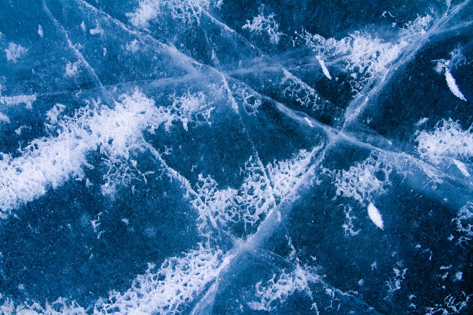
Beautiful ice fracture patterns in the lake ice
While observing the hoist and let-down maneuvers of the array, it was clear the planning had paid off and the right people were doing the right jobs. The data being collected was coming back usable and faster than the project had anticipated, covering a much wider area right off the bat.
One of the best parts of the day was being able to explore the surround area of the camp while the helicopter was flying its tracks through the upper valley. Many areas are controlled and restricted in order to preserve the untouched environment of Antarctica, however there are some established paths and the lake ice is solid providing access to some spectacular scenery.
The mummified remains of a seal that became VERY lost and off track. There are quite a few in these valleys.
Reflections on thin ice
A broad shot of the Canada Glacier on the west side of the lake
Looking across the ice at the massive glacier
The terminus of the Canada Glacier--about a 200' wall of ice
About a 2 mile each way hike on ice for a picture. Well worth it.
Boulders that are carried along and deposited as the glacier melts
A nice airborne shot for a side perspective
Again, while photos look amazing, they hardly express the stark beauty of these valleys. I headed back from this hike to meet the helicopter and take care of that business.
A nice advert for North Face...
Inbound with skyTEM
Final recovery of the day
Gentle placement on terra firma is key
Shut down and debrief time
As we said earlier the flying went extremely well. The pilots got the hang of the operation quickly and performed flawlessly. The project has been extremely happy with the work thus far and are very excited based on the pace of operations to be able to collect a large amount of data in hopes of mapping some of the critical features around here in order to better understand the ecosystem, potentially open doors for new studies and answer some questions posed by previous projects.
That's about all for now. Just this last week left down here before I head home for the holidays. I can't wait to head north. Plenty to do this week. Penguins, PIGs and more later this week. Stay tuned!
View of tabular icebergs embedded in the sea ice en route home.
One of the more interesting, different, risk laden projects we're doing this year is in the helicopter world. There is a Danish project called skyTEM that began flying here last week. It is a huge array slung beneath one of our Bell 212's that is being used to image the ice, the underlying water, sediments, soil and bedrock in order to determine what is happening within the ground beneath our feet--similar to the way a CT scan is a non-invasive glance beneath our skin without leaving a mark. That majority of the project work will be flown in the Dry Valley's here, focusing on Taylor Valley, Taylor Glacier and later the Barnes Glacier here on Ross Island.
The surrounding area map
Day 1 began with the assembly of the array itself. The scale of this is huge. It's about 100' long x 60' wide and flown on a 100-150' long line depending on the amount of background "noise" generated by the helicopter. The team assembled the antenna like a giant erector set you had as a kid, except its made out of Kevlar and the size of your house.
The giant erector set during assembly
Close up of the Kevlar construction
The frame and rigging on ice
Once we looked it over and gave the okay, one of the Bell 212's flew down with its crew for a closer look and for an onsite brief of how this was going to be flown. The gear was tested to ensure the array was "talking" to the helicopter providing track and altitude guidance in reference to its desired route of flight. The operation is like non-other that had been flown prior here and was new ground on many fronts. Lot's of eyes were watching as this was the culmination of many, many months of preparation and work prior just to get the project down here.
Preflight inspection of the rigging
On liftoff, its a delicate, slow and controlled ascent as the initial inspection of all the rigging in-flight is accomplished by the ground handler. Once cleared, the helicopter continues to climb out of its low hover to near 100' tensioning all the lines.
Initial hoist of the rigging.
We have liftoff! 1st calibration flight underway, up to 3000' now.
Once airborne the rig hangs at an angle. With forward velocity, it generates lift, flies level and can be adjusted to an ideal speed based on the quality of the data and wind conditions. For the initial testing, the rig needs to be flown up to around 3,000' above ground in order to get a baseline signal clear of any background "noise" and be able to determine the fingerprint of the helicopter's electromagnetic signature.
Once complete and operational the flight profile of the rig is to be flown dual piloted at 100' above ground level (AGL) over a challenging valley environment with sloping terrain and glaciers. Throw in random 50 knot down-valley winds and things get interesting.
The view from below
In-flight preparing to either land or net the helicopter below
All in all it was an extremely successful day. A couple minor adjustments had to made to the rig and off they went the next day to begin flying the rig throughout the Taylor Valley for the next 2 weeks.
Another report to follow from Lake Fryxell where the team is camped out of currently. Stay tuned for more...