Sunday, November 27, 2011

Greetings from Superman's Fortress of Solitude

Sorry for the radio silence from down south lately.  It's been about a week since my last entry.  This is not due to a holiday, it's really due to NOTHING happening here.  Since last Monday midday, we have not flown once. The weather has been awful.  Pretty much snow, blowing snow, ice crystals, snow pellets, freezing fog the works which all adds up to no flying around these parts.

It is also the week of Thanksgiving here, however since we typically have a six day work week and the holiday falls on a weekday--we observed it last night, Saturday night (as well as a rare two day weekend).  The irony of yesterday is that the aviators have all sat around weathered out this week and the planned day off  for the holiday was absolutely beautiful for flying.  Typical Murphy's Law!

I opted to start off the holiday right with a run and did the 5K Turkey Trot Race here. The good news was it was sunny and looked beautiful out.  Beyond that it was c-c-c-c-c-c-c-c-old and windy!
Ready...set...gooble...
Nearing the turnaround with Mount Discovery in the background
Uphill with Ob Hill in the background
The rest is downhill from here!
I think it was around 14 F with around a 30 knot breeze straight uphill on ice.  The good news was I finished, however I won't be using this time for any future race resume or qualification purposes!  Around 200 folks ran and I did finish in the middle of the pack for the under 40 men's group.  The winner ran around a 20:45 time.  I think I would have trouble doing that on pavement downhill let alone here. Next year I get to change groups to the over 40.  Look out!

The rest of the pre-gorging day was spent out on the sea ice.  The recreation folks put together the first organized tours of the pressure ridges with a mountaineer.  These monoliths are amazing.  The forces of nature are amazing and beautiful.  Its like getting to watch plate tectonics in high speed (i.e. over weeks versus 100 million years).

My immediate takeaway walking among the troughs and peaks of these frozen 25' waves was I know where the writers for Superman came up with the idea for his "Fortress of Solitude"! 
From the comic...
...to reality!

Fire and Ice! Pressure Ridges with Mount Erebus in the background
 The beauty here is amazing.  Pictures are pretty, however hardly do justice to the reality walking through this ice field.

The ice is truly blue.  Nothing touched up on these at all.
A wall 20' of lifted blue ice

A crevasse runs through this ridge
 These ridges are in constant motion.  Tidal forces act upon them daily.  As the cracks form, seawater floods into the voids, freeze and cause uplift.  This in combination with the Ross Ice Shelf flowing into this transition zone causes a mangled mass of blue and white beauty.

Erebus frames by two ridges
Flags mark the safe route.  Wander off and you may slip into a hidden crevasse 

The other beauty of these ridges is that they attract marine wildlife.  These crack do the work for the seals so they do not have to grind their way through the ice to find a breathing hole.  Weddell Seals were the mammal of choice today as we walked through the lazily snorted and rolled over, caring less that we were interrupting their sun bathing.
Life among the ridges.

Huh? Wha? Oh, back to sleep now.
A skua joining in the fun, looking for a spare scrap of fish
Zzzzzzzzz.
A look back through the ice field at Mount Terror as we walk back to Mcmurdo.
I couldn't have imagined a better Thanksgiving down here than what I did.  Lots of fun.  While I wish I was home to spend it with family and friends, this will suffice for now!  Back to the work week.  Hoping for some better weather!   Some neat projects are about to start so I can't wait to check them out and share what I can.

Talk to everyone soon!  Happy Thanksgiving!

Sunday, November 20, 2011

Flight of Pegasus

So the weather finally turned a bit more traditional over the past few days with temps in the -10 below range and snow.  We received about 3-4" of fresh powder last night and it put a nice clean coat over everything. The town is normally very brown from the volcanic soil and rocks around us so its a welcome change.  
Looking out from my dorm across Winter Quarter's Bay to Scott's Hut.

Fresh powder on Observation Hill
A view across the harbor at Hut Point and Scott's Discovery Hut
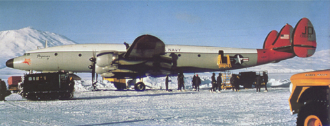
So it's Sunday here, the recreation department tries to offer up different trips and such around the area to see unique sights that most folks normally don't get to see.  Today I signed up for a ride out on the ice shelf to an old plane wreck that happened in 1970.  The aircraft is a C-121 Super Connie (Constellation) that was being flown by VXE-6, the US Navy squadron that supported Operation Deep Freeze up until the late 1990's.  
Before....
The story goes like this, just before 9am on October 8, 1970 the Super Constellation "Pegasus" (BuNo 131644) of VXE-6 departed from Christchurch Airport on a ten and one half hour flight to Antarctica. The Ill-fated Aircraft ended her life in a tangled heap on the ice of the Ross SeaAppropriately named "Pegasus"-the flying horse, this was her seventh year of Antarctic operations.  
The mission was to open up "Operation Deep Freeze 71", destination the ice runway Williams Field, McMurdo Sound, and 2,600 miles away over open frozen water. A routine squadron's flight but was to end in tragic circumstance's ten and one half hours later. Half an hour out from McMurdo, the weather had deteriorated to zero visibility with an intense storm, which had enveloped the base. Low on fuel and no alternative airfield, the aircraft commander was forced to "crash land" the aircraft. After making five approach attempts to minimums they broke out, landed and the right main landing gear was sheered off by an unseen 4' snow drift caused by the storm and winds. The aircraft veered off to the right side of the  ice runway and the "Connie" was destroyed without loss of life.
...and after.

The aircraft remained in the vicinity of Williams Field for the season, however for obvious morale reasons, seeing one of your squadron's wrecked aircraft daily with its wing ripped off in heap was not good for the troops.  The commander decided at the time to haul the wreck out of plain sight about 10 miles away on the ice shelf where the current permanent ice runway is located, now named for its historic neighbor, Pegasus.
Snapshot view of the crash site and surrounding ice shelf

 So its now partially buried in drifting snow and ice about 2 miles from the current airfield location.  We were the first tour of the season, typically by season end, it's dug out enough by curious folks that most of the aircraft is exposed.  It's a neat opportunity to see and spend an afternoon.  How many times can you say you crawled around a plane wreck on an ice shelf? Hopefully, this is my only time--a planned outing!  
A look back at what's left of the empenage
Crawling on top
A look down the fuselage
Kind of cool, right? It's always neat discovering new things to see around here.  Back to my work week now.  Weather permitting, I'm off to go fly tomorrow and then I can't wait for Tuesday--off to South Pole Station!  That will be great.

Friday, November 18, 2011

Off to the Polar Plateau...

Another cool flying day yesterday on the fixed wing side of the house.  Plenty of room on board one of our medium lift, DC-3T Basler aircraft so I opted to tag along to mooch a little flight time and help the crew offload about 6,000 pounds of fuel in support of a survey going on up on the polar plateau.
A view of one of our Twin Otters at the fuel pits (Mt Erebus and Ob Hill in the background)
I headed down to the Sea Ice Runway with the crew and had a little time during preflight to walk around the line and see what's happening down there and grab a coffee from the flight line galley.
One of the survey projects on the Basler (note the radar array under-wing and tail boom as well)
We have a variety of aircraft and missions for each type of aircraft.  Some are flying strictly cargo missions, others are configured for unique survey flying where specialized hardware is installed internally and externally under the wings, through ports and even on the empenage or tail section.
Two ski equipped Baslers ready for business
Basler looking out across the ramp at a ANG LC-130 taxiing our of the ramp for takeoff
A Twin Otter inbound for a fuel stop
A closer look at the survey equipped Basler
Today was a fairly routine day of stockpiling fuel in the field at a remote cache a few hundred miles from McMurdo that enables flights to drop in for fuel to save time and the fuel to return to McMurdo or another prepared field.  The drums are loaded up internally each in a  standard 55 gallon drum or about 400 lbs apiece. We flew direct to the center of the map below labeled BYG.
 En route the flying is always gorgeous.  Across the Trans-Antarctic Mountains we went, where as you can see, was a beautiful day, just a bit bumpy as you cross the mountains up onto the Polar Plateau where the cold air spills down through the mountain passes to lower elevations, speeds up, causing what are known as katabatic winds and a nice mountain wave.
A glance at the upper Watson Glacier and Prebble Ice Falls
Prebble Ice Falls
So after the beauty of the mountains, comes the white endless abyss that is the polar plateau.  White as far as you can see, and then some.  We picked our way through the ice field and landed on a nice section of crevasse free ice.  The elevation where we were was about 7,500'--over 4,000' of which is glacial ice.
High atop the polar plateau--not a runway in sight
We offloaded the fuel in the thin air, marked the cache flags so it could be found after being buried and departed in about 15 minutes after landing--the -10 below and 30 mph wind helps motivate you along in your work.

We returned back to Mcmurdo for another load and flew most of the return leg.  Back over the mountains and in we went for a successful round trip.  Flying here is great--better than any office day by far!  

Well back to my Saturday at work now.  Weather has rolled in today and put a damper on flight ops for a bit.  We can't complain though as its been fantastic weather for 2 straight weeks here. A little delay for now, hopefully the whole day isn't a wash.  Take care all! Stay tuned for more.

Byrd Glacier Rescue

 Have you ever broken down on the side of the road in what appears to be the middle of nowhere?  How about in the middle of a flowing glacial ice stream 200 miles from the nearest service station?  No?  Well that's what happened 2 nights ago here.

We got a call from one of our helo's out in the deep field supporting a project on Byrd Glacier studying the flow rate of this outlet glacier which flows from the polar plateau, through the Trans-Antarctic Mountains and exits to the Ross Ice Shelf.  The helicopters are flying to numerous stations across the expanse of the glacier installing GPS recorders that will be recovered at the end of the summer in February.  [Checkout a post I wrote with more detail from last season here.] While on its final stop for the day and shutdown one of the starter-generators on board failed.

So we gathered up a maintenance crew, some parts, tools, survival gear and a helo--so off we went, and went and went and went.  I remembered one of the MANY reasons why I like flying jets.  Speed.  The mighty Bell 212 was not gifted in that regime of flight.  So off we went at 90 knots across the flat white expanse of the Ross Ice Shelf in search of a little red dot on the ice.
Flying through a pass along the Merrick Glacier
After about 90 minutes you come upon the mountain range that borders the ice shelf and things get beautiful quickly.  Passing 10,000' peaks and glaciers named after historic people and expeditions from Antarctica's past is awe inspiring. 
A view up the Devries Glacier
Passing between numerous peaks and over ridgelines, we popped out high above the twisted earth below known as the Byrd Glacier.  25 miles across and 100 miles+ long this is no place I'd want to look for a place to land.  However that's what our pilots are doing daily all in the name of science. 100' deep crevasses, peaks, valleys, all slick with blue ice--nothing flat--No thanks.  
Looking for a landing zone. Yes we landed here. 
Further up near the source of the stream, was where the aircraft was broken.  The GPS recorders are placed up here allowing them to flow down stream over the next 3 months and recovered further down the outlet end of the glacier.  Fortunately the ice wasn't as bad at the source, still riddled with crevasses however not nearly as broken apart yet. We had about a 100'x15' area to safely land 2 helos on.
Green flags placed by our mountaineer marking a large hidden or "bridged" over crevasse
Thankfully our mechanics were good, found the problem and whacked the problem area with a 20 ounce hammer helping motivate the ceased up part loose, starting right away--all within 45 seconds of stepping out of the aircraft. Classic maintenance fix.  All in a days work!   
Wait! Don't leave us--we're not fixed yet!

Grabbing gas at the nearby Darwin Glacier fuel cache with our friends 
Flying home through some barren desert like terrain.
 So an uneventful low-level transit home through some more great terrain.  I love the views from this office!