 |
| PHI's Bell 212 |
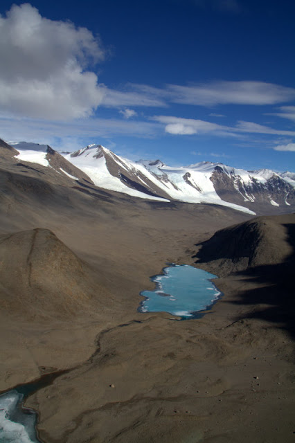
They are a glaciologist's dream. As the ice off the polar plateau flows, it carves out this section of granite leaving its mark on the constantly changing topography. The shear scope of these glacial flows is epic. Words are difficult in describing the shear beauty along each Valley.
So we took off from McMurdo's helipad in one of the Bell 212's to the east (direction is all a bit different at the bottom of the world--this is a whole different subject for later). We transited across the Ross Sea ice  towards the valleys which took about 30 minutes. We proceeded over the western edge of the sea ice and entered the Taylor Valley flying close to "map of the earth" low level flying. The winds were light in the valleys so turbulence was minimal and we proceeded up valley towards Bonney Lake which is at the outflow of the Taylor Glacier. We proceeded to head to Bonney Lake and do 4 round trips to the camp to pick up gear, empty on the return leg, giving us the freedom to explore and see the surrounding beauty that is Antarctica. There is so much I could say but hopefully the pictures speak for themselves. This was an amazing flight and can't believe this is my job.
 towards the valleys which took about 30 minutes. We proceeded over the western edge of the sea ice and entered the Taylor Valley flying close to "map of the earth" low level flying. The winds were light in the valleys so turbulence was minimal and we proceeded up valley towards Bonney Lake which is at the outflow of the Taylor Glacier. We proceeded to head to Bonney Lake and do 4 round trips to the camp to pick up gear, empty on the return leg, giving us the freedom to explore and see the surrounding beauty that is Antarctica. There is so much I could say but hopefully the pictures speak for themselves. This was an amazing flight and can't believe this is my job.
 |
| Lake Fryxell at the head of the Taylor Valley |
 |
| Approaching the field camp at Bonney Lake |
 |
| Lake Hoare at the base of the Suess Glacier |
 |
| Continuing up the Taylor Valley |
 |
| Picking up sling loads at the Bonney Lake camp LZ |
 |
| On the deck at Marble Point -- fuel, food and a stretch |
 |
| Me trying to figure out the voodoo that is flying helo's |
 |
| Gargoyle Ridge in the Asgard Range in the Wright Valley |
 |
| The Schlatter Glacier and snow field tucked between the mountains of the Asgard Range |
 |
| The confluence of the Taylor and Ferrar Glaciers, the polar plateau ice fall is in the far background |
 |
| The Rhone Glacier |
 |
| The Lacroix and Suess Glaciers flying down valley to drop off a load of gear back at Marble Point |
 |
| The ice edge en route back to McMurdo. The edge itself is a sheer 150' ice cliff. |
 |
| Departing Marble Point to return to McMurdo after 4 hours of Valley Flying! This is Mt Erebus, 12,400' volcano which is directly above Mcmurdo station. |
 |
| The ice breaker Odin in the channel between Mcmurdo and ice edge. It keeps the lane open for the resupply and research vessels that come into port. Mt Erebus in the background. |
 |
| On final into Mcmurdo. This is "home" to about 1,000 of us. My room is on the left edge of town. Everything is black because we are on volcanic soil. Again Mt Erebus looms in the background. |
Well, that's about it! It's Saturday, the end of my "week", hope to go hiking to a penguin colony tomorrow if its not too cold. The temps finally beginning to become normal--its around 12-13 degrees F now. The next few weeks will really start dropping quickly too. And yes I am serious about the penguins....


1 comment:
Awesome, Andy! We know Tammy has first dibs, but Leigh and I want to be your second visitors when you're ready. Very cool!! Can't believe the penguin deal...
Post a Comment